Bayram Cigerli Blog

Bigger İnfo Center and Archive
  • Herşey Dahil Sadece 350 Tl'ye Web Site Sahibi Ol

    Hızlı ve kolay bir şekilde sende web site sahibi olmak istiyorsan tek yapman gereken sitenin aşağısında bulunan iletişim formu üzerinden gerekli bilgileri girmen. Hepsi bu kadar.

  • Web Siteye Reklam Ver

    Sende web sitemize reklam vermek veya ilan vermek istiyorsan. Tek yapman gereken sitenin en altında bulunan yere iletişim bilgilerini girmen yeterli olacaktır. Ekip arkadaşlarımız siziznle iletişime gececektir.

  • Web Sitemizin Yazarı Editörü OL

    Sende kalemine güveniyorsan web sitemizde bir şeyler paylaşmak yazmak istiyorsan siteinin en aşağısında bulunan iletişim formunu kullanarak bizimle iletişime gecebilirisni

Roman History etiketine sahip kayıtlar gösteriliyor. Tüm kayıtları göster

Freshen Up With Archaeology Friday (Post IX)

Tonnes of news over the past week, here are the highlights.

Three Kingdoms' Tomb Holding Warrior Discovered:

About 1,800 years ago, at a time when China was breaking apart into three warring kingdoms, a warrior was laid to rest.

The tomb (photo from Chinese Archaeology)
Buried in a tomb with domed roofs, along with his wife, he was about 45 years old when he died. Their skeletal remains were found inside two wooden coffins that had rotted away. Archaeologists don't know their names but, based on the tomb design and grave goods, they believe he was a general who had served one or more of the country's warring lords, perhaps Cao Cao and his son Cao Pi.

His tomb was discovered in Xiangyang, a city that, in the time of the Three Kingdoms, was of great strategic importance. Rescue excavations started in October 2008 and now the discovery is detailed in the most recent edition of the journal Chinese Archaeology. (The report had appeared earlier, in Chinese, in the journal Wenwu.)

Live-Science covers the issue well, here.

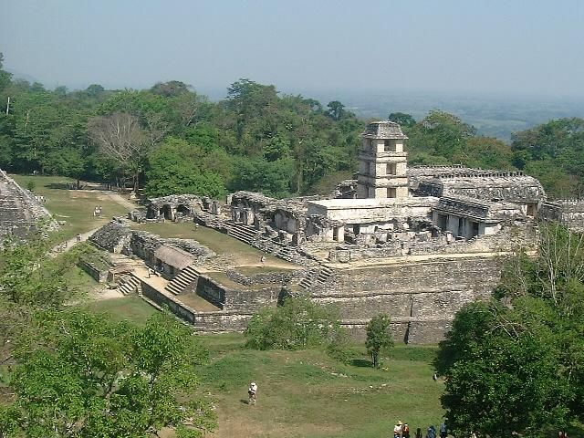
 Largest Ancient Dam Built by Maya in Central America:
 (Source)
The dam (photo from the University of Cincinnati researchers)
Recent excavations, sediment coring and mapping by a multi-university team led by the University of Cincinnati at the pre-Columbian city of Tikal, a paramount urban center of the ancient Maya, have identified new landscaping and engineering feats, including the largest ancient dam built by the Maya of Central America.

That dam -- constructed from cut stone, rubble and earth -- stretched more than 260 feet in length, stood about 33 feet high and held about 20 million gallons of water in a human-made reservoir.

These findings on ancient Maya water and land-use systems at Tikal, located in northern Guatemala, are scheduled to appear this week in the Proceedings of the National Academy of Sciences (PNAS) in an article titled "Water and Sustainable Land Use at the Ancient Tropical City of Tikal, Guatemala." The research sheds new light on how the Maya conserved and used their natural resources to support a populous, highly complex society for over 1,500 years despite environmental challenges, including periodic drought.

The paper is authored by Vernon Scarborough, UC professor of anthropology; Nicholas Dunning, UC professor of geography; archaeologist Kenneth Tankersley, UC assistant professor of anthropology; Christopher Carr, UC doctoral student in geography; Eric Weaver, UC doctoral student in geography; Liwy Grazioso of the Universidad de San Carlos de Guatemala; Brian Lane, former UC master's student in anthropology now pursuing doctoral studies at the University of Hawaii; John Jones, associate professor of anthropology, Washington State University; Palma Buttles, technical staff senior member, SEI Carnegie Mellon University; Fred Valdez, professor of anthropology, University of Texas-Austin; and David Lentz, UC professor of biology.

Starting in 2009, the UC team was the first North American group permitted to work at the Tikal site core in more than 40 years.
Detailed in the latest findings by the UC-led efforts are
  • The largest ancient dam built by the ancient Maya of Central America
  • Discussion on how reservoir waters were likely released
  • Details on the construction of a cofferdam needed by the Maya to dredge one of the largest reservoirs at Tikal
  • The presence of ancient springs linked to the initial colonization of Tikal
  • Use of sand filtration to cleanse water entering reservoirs
  • A "switching station" that accommodated seasonal filling and release of water
  • Finding of the deepest, rock-cut canal segment in the Maya lowlands
 Alexander the not-so Great: History through Persian eyes:
The BBC radio launched a three-part podcast of Persian history presented by


The portraits painted on to panels that covered the heads of mummies form part of an exhibition at the city's John Rylands Library. The panels, which have rarely been shown in public, were bequeathed to Manchester Museum by cotton magnate Jesse Haworth in 1921.

The museum's Egyptology curator Campbell Price said they depicted people who looked "strikingly modern". The paintings, known as Fayum portraits after the region near Cairo where they were found, were discovered on archaeological digs in 1888 and 1911 by William Flinders Petrie.
They date back to about AD 150, when Egypt was part of the Roman Empire.

Petrie's excavations were funded by Haworth and many of his finds went on to form part of Haworth's private Egyptology collection. Mr Price said the institution was "incredibly excited" to be showing the portraits.
"What is particularly fascinating about them is that the people portrayed by the artists often look as if they are Greek and Roman, rather than traditionally Egyptian, indicating just how much of a melting pot Egypt was 2,000 years ago," he said.
The panels were found by Victorian archaeologist William Flinders Petrie
"The portraits can often be dated by their hairstyles or jewellery - showing how quickly fashions changed almost two millennia ago. They appear strikingly modern and grab your attention in ways traditional Egyptian mummy masks do not."
The University of Manchester's Dr Roberta Mazza, who has helped curate the exhibition, said the artefacts offered "a rare window into people's lives at a key point in Egyptian history, when Egypt was part of a wider Mediterranean world dominated by the Roman Empire".

Papyri containing extracts of the apocryphal Gospel of Mary, the original of which has been credited by some to Mary Magdalene, and census documents are also on show.
The papyri were collected by John Rylands Library founder Enriqueta Rylands in the early years of the 20th Century.
Exhibition co-curator Professor Kate Cooper said the papers showed "a forgotten side of history".
"For example, the Gospel of Mary fragment argues that women should have a leadership role in the Christian church, a view which the medieval Church tried to suppress," she said.

 Golden medallions from Romen era found in Bulgaria:

Some positive news coming out of Bulgaria this week, in light of the recent attack.
Photo of the medallions
Golden medallions featuring inscriptions and images found in a gravesite dating to the Roman era in Debelt, a village in the region of Bourgas on Bulgaria’s Black Sea coast, have been identified by archaeologists as being from the second century CE.
According to archaeologists, the graves are those of veterans of the eighth legion of Augustus. They are in the western part of the ancient Roman colony of Deultum, according to a report on July 17 2012 by public broadcaster Bulgarian National Television.
Today the gravesite is next to a street in the latter-day village of Debelt. Deultum, in its time, was known as “Little Rome in Thrace”, the report said.
The find was made by accident while people were pouring concrete for construction. The vibration of the concrete mixer caused the surface to crack and a tomb was found.
 
Krasimira Kostova, director of the Archaeological Museum in Debelt, said that the find was of extremely high value. The valuable gifts were evidence that the people who lived there were of high status.
The finds included golden jewellery and a needle, beads and scrapers used by the ancient Romans for bathing and massage and in medicine as a means of inserting medication in the ears and throat, the report said. All of these were signs of urban life in what was then an important place in the Roman empire.
An inter-ministerial committee will decide what will become of the site. According to the report, Debelt archaeological reserve is the only one in Bulgaria to have “European archaeological heritage” status.


Archaeologists are pretty convinced they have found the remains of Mona Lisa (AFP Photo/Claudio Giovannini)
Scientists claim that they might have found the skeleton of the woman who posed for Leonardo Da Vinci’s most famous painting. Most art historians agree that Lisa del Giocondo was the woman who inspired Da Vinci to create his iconic work.

Now the archaeologists working in Florence are pretty convinced they have found the remains of the lady, merchant Francesco del Giocondo’s wife Lisa Gherardini.

The skeleton was unearthed beneath the medieval Convent of Saint Ursula in Florence. Knowing she became a nun after her husband died and lived in the convent until her death in 1542, a team of archaeologists began excavation works at the abandoned convent last year.

A female skull along with other fragments of human bones will undergo DNA analysis and compared with the DNA data in the bones of the Lisa Gherardini’s children to establish the truth. If the scientists confirm the DNA belongs to Lisa Gherardini, then specialists will try to reconstruct her face and try to solve the mystery of her smile.
“We don't know yet if the bones belong to one single skeleton or more than one,” archaeologist in charge of the excavation works Silvano Vinceti explains. Yet in his opinion the find confirms, “that in St.Ursula convent there are still human bones and we cannot exclude that among them there are bones belonging to Lisa Gherardini
Great Wall of China Longer Than Previously Thought:
 (Source)
The Great Wall of China is already the longest man-made structure in the world but we may have to start calling it the Greater Wall of China.

A five-year archaeological survey done by the State Administration of Cultural Heritage (SACH) found that the total length of the Great Wall was 13,170 miles long and reached across 15 provinces.
This is more than twice the length previously thought. In 2009, SACH reported that the wall was 5,500 miles and stretched across 10 provinces.

The previous estimation particularly refers to Great Walls built in the Ming Dynasty (1368-1644), but this new measure includes Great Walls built in all dynasties,” Yan Jianmin, the office director of the China Great Wall Society, told the China Daily.
Archaeologists and mapping experts conducted field surveys in 15 provinces and found 43,721 sites related to the Great Wall, according to the report.
As thousands years pass, some ground structures disappear, and we do not know where the walls used to be. When some local governments or companies develop the land, like coal mining or building new roads, they destroy the remaining parts under the ground,” Jianmin told the China Daily.
The survey, which began in 2007, is part of the Great Wall protection project, which aims to preserve and protect the wall.
Now we are clear about the location of the Great Wall, so the government can take steps to protect the walls, and local governments are clear about their responsibility to protect the walls,” Jianmin told the China Daily.
Construction of the Great Wall began more than 2,000 years ago to ward off invasions, but only 8 percent of the wall is still standing today. The Great Wall is one of the Seven Wonders of the World and was declared a UNESCO World heritage site in 1987.

Article of the Week: How did Persian and Other Western Medical Knowledge Move East, and Chinese West?  A Look at the Role of Rashīd al-Dīn and Others:

Written by  Paul D. Buell, a professor at the Western Washington University.
The name of Rashīd al-Dīn (1247-1317) is associated with the transmission of considerable medical lore from China to Mongol Iran and the Islamic World. In fact, Rashīd al-Dīn was only at one end of the exchange, and while Chinese medical knowledge, including lore about pulsing and the Chinese view of anatomy, went west, Islamic medical knowledge went east, where Islamic medicine became the preferred medicine of the Mongol elite in China. The paper traces this process and considers who may have been involved and what specific traditions in an ongoing process of medical globalisation

Book Review: Jerusalem: The Biography

I've always been a keen admirer of Jerusalem and after reading the book's blurb (see below), I knew this was one of the best books around. It did not disappoint.
"Jerusalem is the universal city, the capital of two peoples, the shrine of three faiths; it is the prize of empires, the site of Judgement Day and the battlefield of today’s clash of civilizations. From King David to Barack Obama, from the birth of Judaism, Christianity and Islam to the Israel-Palestine conflict, this is the epic history of three thousand years of faith, slaughter, fanaticism and coexistence.
 
How did this small, remote town become the Holy City, the “center of the world” and now the key to peace in the Middle East? In a gripping narrative, Simon Sebag Montefiore reveals this ever-changing city in its many incarnations, bringing every epoch and character blazingly to life. Jerusalem’s biography is told through the wars, love affairs and revelations of the men and women—kings, empresses, prophets, poets, saints, conquerors and whores—who created, destroyed, chronicled and believed in Jerusalem. As well as the many ordinary Jerusalemites who have left their mark on the city, its cast varies from Solomon, Saladin and Suleiman the Magnificent to Cleopatra, Caligula and Churchill; from Abraham to Jesus and Muhammad; from the ancient world of Jezebel, Nebuchadnezzar, Herod and Nero to the modern times of the Kaiser, Disraeli, Mark Twain, Lincoln, Rasputin, Lawrence of Arabia and Moshe Dayan.
"
This book was written by Simon Sebag Montefiore, his last name already being a significant part in Jerusalem's history, a Cambridge University alumni who studied history and is already well known throughout much of the literary world for his previous award-winning books, Catherine the Great & Potemkin which were shortlisted for the Samuel Johnson, Duff Cooper, and Marsh Biography prizes. 

His book "Stalin: The Court of the Red Tsar" won the History Book of the Year Prize at the British Book Awards. "Young Stalin" won the Costa Biography Award (UK), the LA Times Book Prize for Biography (US), Le Grand Prix de la Biographie Politique (France) and the Kreisky Prize for Political Literature (Austria). Montefiore’s books are published in over 35 languages. He is also the author of the  novel, Sashenka. (For a more in-depth biography)
 
 The book starts brilliantly with a prologue of the siege of Jerusalem of 70AD, by the Roman legions of (future-emperor) Titus against the Jewish rebels who occupied the city. The book officially begins with the Canaanite era of Palestine, going through the biblical eras of King David and Solomon. From the times of the Persians , Macedonians and Romans, to the time of the Byzantines, Arabs, Crusaders, Mamluk, Ottomans and British.

Simon Sebag Montefiore ©Hugo Burnand
The most stunning thing about this book is that it is remarkably neutral (that's a feat when considering a controversial topic like Jerusalem's history). "Jerusalem, the Biography" is a fitting title since the book is written as a biography, through the people who made Jerusalem, starting with King David and ending with Barrack Obama, over a span of 3000 years. Each section is about a person who, made, destroyed, believed in, or fought for Jerusalem, some are ordinary people, some are monsters and dictators. There is massacre, siege, blood, violence, but also brilliant, so very much brilliant poetry.

The story of Jerusalem, is truly (as the author expressed) the story of the world, as well, of the Middle East, of religion, of holiness, of empire! The goosebumps I had when I read about some of of the greatest philosophers, the Arab historiographer "Ibn Khaldoon" in the book, about Suleiman the Magnificent, Caliph Muawiya, Saladin Dynasty, the entire Outremer era with a brilliant inclusion of William of Tyre, the Druze princess and angelic voiced Singer "Asmahan", the Hashemite (Sherifian) Dynasty, and most exciting to read was some poignant poetry by Nizar Qabbani.

This book should be the "must-read" guide for journalists and public figures in the Levant region, the book isn't just a simple retelling of facts, it is much more. With stories, anecdotes, and pages and pages of researched history you really feel as if you are stepping back through time and experiencing Jerusalem's history first hand.

And if the 650 pages of 3,000 years of Jerusalemite history are not enough, the book even has multiple photos, and multiple maps of Jerusalem's Old City, of all the quarters, throughout much of its history, right up to 1948. I strongly recommend this book to anyone with an interest in Jerusalem, or the Middle East in general. This has been one of the best books I've read

Freshen Up With Archaeology Friday (Post IV)

As always, the realm of archaeology has been bustling this past week and here's the lowdown:

 Archaeologists Uncovering the Heart of Ancient Aelia Capitolina:

Recent excavations by a team of archaeologists just west of Jerusalem's famous Western Wall and Plaza are illuminating scholars while raising new questions about 2nd Century AD Jerusalem.

Under the directorship of Shlomit Weksler-Bdolah, Alexander Onn, Shua Kisilevitz and Brigitte Ouahnouna of the Israel Antiquities Authority, the systematic excavations were conducted between 2005 and 2010 and revealed a major Roman-constructed thoroughfare that sliced through the heart of 2nd century Jerusalem, the period that followed the downfall of the First Jewish Revolt and saw the transformation of the city into a newly Romanized city, renamed Aelia Capitolina.

A detailed article about their discoveries has been published in an article entitled Layers of Ancient Jerusalem in the January/February 2012 issue of Biblical Archaeology Review. This article relates the results thus far of excavations that progressed as far down as the underlying 8th century B.C.E. quarry used by stone cutters to produce the well-known limestone building blocks used to construct much of ancient Jerusalem's monumental structures.

A model of a typical Israelite house during the First Temple period

Just above that quarry, the archaeologists also found part of what has been interpreted as a large "four-room" house laid out in a style typical of Israelite house structures of the First Temple period, featuring three long, parallel rooms and a larger room extending perpendicularly across the ends of the other three (see model example pictured right).

Within the structure was found several personal seals (small round or elliptical incised pieces of clay used, for example, to sign and seal ancient correspondence) bearing Hebrew names.


Within its dirt fill were hundreds of pottery shards and fragments of clay zoomorphic and anthropomorphic figurines, all dated to the latter part of the First Temple period, between the 8th and 6th centuries B.C.E. The archaeologists suggest the likelihood that the structure was destroyed by the Babylonians in 586 B.C.E., along with the rest of the city, but lack of evidence of any fire normally associated with the Babylonian destruction raises other possibilities, such as an earthquake.


In any case, the team suggests that the structure represents a house that was inhabited by members of Judah’s social elite, as evidenced by the seals, and that other material found within the house indicate a possible cultural connection to Assyria.


If you are interested in the topic, you can read more here.

Mystery of Pompeii's Trashy Tombs Explained:

The tombs of Pompeii, the Roman city buried by a volcanic eruption in A.D. 79, had a litter problem. Animal bones, charcoal, broken pottery and architectural material, such as bricks, were found piled inside and outside the tombs where the city's dead were laid to rest 

To explain the presence of so much garbage alongside the dead, archaeologists have theorized that 15 years before the eruption of Mount Vesuvius, an earthquake left Pompeii in disrepair.

However, this theory is unlikely, according to an archaeologist who says the citizens of Pompeii may have just been messy, at least by modern, Western standards.
"We tend to assume things like that are universal, but attitudes toward sanitation are very culturally defined, and it looks like in Pompeii attitudes were very different than ours," said Allison Emmerson, a graduate student studying Roman archaeology in the classics department of the University of Cincinnati.
Composite photo, showing why tombs were filthy(Photo from Porta Stabia
Archaeological evidence from the last 15 years indicates that the city likely did not fall into ruin after the earthquake in A.D. 62; rather than flee, citizens appear to have rebuilt, reconstructing public spaces and elite houses.

When the eruption buried the city, new tombs were still being built and the city appeared prosperous, according to Emmerson.


"It just didn’t make sense that trash would mean the tombs weren't being used," she said.   
In fact, the tombs weren't unique; excavators have found the same sort of household garbage in the city streets, along the walls of the city, even on the floors of homes.

When Emmerson excavated a room in a house that appears to have also served as a restaurant, she found a cistern for storing water between two garbage pits packed with broken pottery and food waste, such as animal bones, grape seeds and olive pits.


No evidence has been found for a system for handling garbage or for dedicated dumps.
"The closest thing that has been found is a giant heap of garbage outside the city walls," she said.
The residents of Pompeii also appear not to have shared our conventions on burial. As Romans, they were primarily concerned with being remembered after death, so they sought tombs in high-traffic areas. Since Roman law and custom forbid cemeteries inside the city, the tombs ringed the city walls, and clustered at its gates.

The walls of the tombs also served as the billboards of the day, bearing official graffiti announcing gladiator fights, and political advertisements for candidates for office in red paint. Other graffiti was of the "bathroom" variety, Emmerson said. These included more obscene versions of "I had a girl here," and messages back and forth scratched into the plaster of the tombs.


Emmerson is scheduled to present her work, which examines how Pompeii's tombs reflect the culture at the time, on Saturday (Jan. 7) at the annual meeting of the Archaeological Institute of America in Philadelphia.

Ancient Capital of Cambodia Wilted When Water Ran Low:

Angkor, the ancient city in Cambodia that was the seat of the Khmer empire, flourished from the 9th to the 15th century. Today, tourists still appreciate the remnants of its architecture and sophisticated hydro-engineering systems, composed of canals, moats and large reservoirs known as barays. 


Researchers now studying sediments from one of the reservoirs report that prolonged droughts and overuse of the soil may have interfered with Angkor’s water management system and led to the empire’s decline.

“When Angkor collapsed, there was a drop in water levels,” said Mary Beth Day, an earth scientist at the University of Cambridge in England. “And much less sediment was delivered to the baray at the time.”
Angkor’s population may have been growing, and the soil may have been stressed from aggressive use, she said. 
“The sediment being delivered to the reservoir during Angkor times was more weathered than the sediment being delivered post-collapse,” she said. “The land was used fairly aggressively for agriculture, as opposed to when people left.” 
Ms. Day sampled six and a half feet of sediment core from Angkor that allowed her to study its physical properties, like the abundance of various elements and the ratio of sand to finer-grained materials.
She and her colleagues published their research in the current issue of The Proceedings of the National Academy of Sciences.

Yarrow is King Arthur’s final resting place – archaeologis:

The Yarrow Stone marks the grave of King Arthur, a literary archaeologist claimed this week!

The alleged grave of the semi-legendary King Arthur

Damian Bullen said there was a consensus among academics that the Liberalis Stone (another name for the Yarrow Stone) was the burial ground of two Christian princes who reigned in the fifth and sixth centuries AD – and one of those, he believes, was King Arthur.

Mr Bullen, 35, of Edinburgh, said: “When we strip away the mediaeval romancing of our legendary king, we are left with genuine nuggets of historicity. One of them is the stone at Yarrow which I am convinced is his grave marker.”

The famous monarch is reputed to have died with his nephew, Mordred (Medrawt), in a crooked glen, which Mr Bullen said matches the river bends in the Yarrow Valley near the Liberalis Stone.
Ploughing in the area 300 years ago revealed a large flat stone inscribed in Latin, saying it was a memorial to “the most famous princes Nudus and Dumnogenus. In this tomb lie the two sons of Liberalis”.
Mr Bullen went on: “At first glance it seems that Prince Nudus and Prince Dumnogenus were the sons of King Liberalis, but there is more to these names than meets the eye.
“Calling our two princes ‘sons of Liberalis’ would be a poetic way of saying that they were very noble princes (and) in the context of a burial chamber, the word Nudus (which implies loss of one’s material possessions) is surely used as a deterrent to would-be grave robbers.” 
He suggests Dumnogenus, instead of being a prince, means ‘born of the Dumno’, which he takes as referring to the Dumnonii tribe of ancient Britons in Cornwall, Devon, Somerset and Dorset.

“This knowledge renders the inscription as,Here lie two famous and very noble princes of Dumnonia, buried without possessions’. Of all the princes of antiquity who have heralded from this region, there is one who stands head and shoulders above all the rest – King Arthur. That he died with a family member – Mordred – fits the inscription on the Yarrow Stone completely.”
He claimed the monks of Glastonbury, where some believe Arthur to be buried, made the story up to raise money.

Mr Bullen notes there are battlefield burials in the area and he suspects Arthur’s corpse was the well-preserved skeleton found on Whitehope Farm in the mid-19th century, but which was gradually lost to curio-seekers.

And from letters dating back to the period, the literary archaeologist also thinks King Arthur’s skull may be in the vaults of a local museum.
Asked to comment on Mr Bullen’s hypothesis, Selkirk historian Walter Elliot said: “Mr Bullen has certainly researched the Yarrow Stone and the various stories about Arthur very well. Whether the two can be joined together is a matter of question.
“Arthur, if he existed, was never a king, but the war leader of the Christian Welsh speakers against the pagan Anglo-Saxons, and the Yarrow Stone is on the linguistic division between the two languages. So far, so good. Arthur is claimed as a local hero from Orkney to the Continent and his graves are many. This is a tricky subject."

Slaves or not, Babylonians were like us, says book:

From Physorg.com

One of the tablets used in the book.
They got married, had children, made beer. Although they lived 3,500 years ago in Nippur, Babylonia, in many ways they seem like us. Whether they were also slaves is a hotly contested question which Jonathan Tenney, assistant professor of ancient Near Eastern studies, addresses in the newly released "Life at the Bottom of Babylonian Society: Servile Laborers at Nippur in the 14th and 13th Centuries, B.C." (Brill).


The book is based on Tenney's dissertation at the University of Chicago, for which he received the 2010 Dissertation of the Year Award by the American Academic Research Institute in Iraq.
Some previous scholars identified the 8,000-strong group of government workers as temple employees. "But the problem is the records included food for little babies, which didn't make much sense," says Tenney, who joined the Cornell faculty this past fall. "And sometimes the workers ran away, and when they were captured they were put in prison."


Tenney translated more than 500 in his hunt for the truth about these weavers, musicians, "water sprinklers" and others in service to the governors of Nippur. By using quantitative measurements to create , he was able to look at , family structure and the legal status of this population. He then compared the Babylonian group's demography with other better-studied groups, such as those in Roman Egypt, medieval Tuscany and on American slave plantations.


"Whether they're slaves is not what's valuable to me about this work," Tenney says. "The point is we don't have an historical demography of Babylonia at all. We don't even know how many people were living there at any given time." His book is the most detailed study yet done of any population group in Babylonia.

The picture Tenney draws of family life in this servile population is surprising in its mundanity. By far the majority of households were nuclear, husband-wife-children or a with children, usually a widow, instead of slaves living together or in groups. Tenney was able to track some families for as long as 32 years.

"As you start to work with slavery you realize how many misconceptions we have," he says. "Being a slave doesn't necessarily mean you can't have a family life and raise children and develop your own individual culture and identity. I think that slavery and freedom exist on a continuum of varying degrees."  He left it to his readers to decide where the Babylonians about whom he wrote fit on that continuum.

The tablets Tenney translated were excavated by scholars from the University of Pennsylvania in the 1890s in what is now Iraq; they are some of the earliest Babylonian texts ever found. Tenney will publish the raw data from his research in the forthcoming "Middle Babylonian Administrative and Legal Documents Concerning the Public Servile of Nippur."


Video of a Roman helmet's 'astounding' Restoration:

Roman helmet's 'astounding' restoration

The helmet, after its restoration (from the Telegraph)
A Roman helmet which was buried in a Leicestershire field for around 2,000 years has been displayed at the British Museum.

It was in hundreds of pieces when it was found in Market Harborough, in 2000, and has since been put back together.

Ken Wallace said when he discovered the helmet the metal fragments looked like "crushed cornflakes".

Mr Wallace added that he was amazed by its restoration by experts at the British Museum.

The helmet will go on show in the Harborough Museum on 28 January.

Claim of Maya ruins in Georgia sparks controversy:

A claim that the Mayans left stone ruins in the mountains of North Georgia has sparked a controversy. The claim was made by Richard Thornton, an architect, who says he has been studying the history of the native people of southeastern United States.
The now-controversial Mayan Ruins in Georgia

According to Thornton, in an article on Examiner.com, architects have long recognized that there are significant similarities between the architectural forms and town plans of Maya civilization in Mexico and ruins of southeastern United States.

Thornton writes that archeologists do not link the ruins in southeastern United States with Mayans of Mexico because of their "unfamiliarity with the descendants of the Southeastern mound-builders, tribes such as the Creeks, Alabamas, Natchez, Chitimachas and Choctaws."
Thornton claims there is a link between the ancient Mayans and the indigenous people of Georgia. He argues that the languages "of the Creek Indians contain many Mesoamerican words." Thornton's thesis is that when the Maya civilization declined in Central America, at least part of the population migrated to Georgia in southeastern U.S.A. He writes on Examiner.com:
"Historians, architects and archaeologists have speculated for 170 years what happened to the Maya people. Within a few decades, the population of the region declined by about 15 million. Archaeologists could not find any region of Mexico or Central America that evidenced a significant immigration of Mayas during this period, except in Tamaulipas, which is a Mexican state that borders Texas on the Gulf of Mexico. However, Maya influence there, seemed to be limited to a few coastal trading centers. Where did the Maya refugees go? By the early 21st century, archaeologists had concluded that they didn’t go anywhere. They had died en masse."
Thornton claims that the conclusion by archaeologists that the Mayans "didn’t go anywhere, they died en masse," is wrong. He claims that a 1,100-year-old archeological site near Georgia's highest mountain Brasstown Bald, is the fabled Mayan city of Yupaha the Spanish explorer Hernando de Soto, searched for unsuccessfully in 1540. He writes:
"The name of Brasstown Bald Mountain is itself, strong evidence of a Maya presence. A Cherokee village near the mountain was named Itsa-ye, when Protestant missionaries arrived in the 1820s. The missionaries mistranslated 'Itsaye' to mean 'brass.' They added 'town' and soon the village was known as Brasstown. Itsa-ye, when translated into English, means 'Place of the Itza (Maya).'”
Thornton cited the work of an archeologist Mark Williams, of the University of Georgia. The archeologist reacted to the article and posted a comment on the article page on Examiner.com:
"I am the archaeologist Mark Williams mentioned in this article. This is total and complete bunk. There is no evidence of Maya in Georgia. Move along now."
But Mayan history and archeology enthusiasts who had taken interest in Thornton's claim, apparently in connection with the Mayan 2012 apocalyptic prophecies, took exception to Williams ticking off Thornton.
In the comments section of the article, someone criticized Williams, saying: "Your response to this article is completely pompous and arrogant. Is the whole article 'bunk' or just the part that mentions you being 'a highly respected specialist in Southeastern archaeology'? If examiner.com is incorrect in their findings and research, then please, by all means, enlighten the rest of us."
Another accused Williams of disrespecting "the Public at large." Yet another person wrote that he would "urge the state of Georgia to cut off funding for Williams' academic department at the University." 

Thornton says he is surprised at the reaction to Williams' comment. But he claims that he was able to connect Mayan civilization to Georgia mostly from evidence of oral history. Thornton argues there are place names in Georgia and North Carolina that sound Mayan and the stone ruins near Brasstown Bald have structures similar to those found in Central American Mayan sites. 

Freshen Up With Archaeology Friday (Post II)

A lot of things have been going on since last week and this all should be a good summary of it :

Did Malaria cause the Fall of Rome?

There has never been any real proof of Malaria having been present at all in the Roman Empire. While there are several mentions of a disease sounding very similar to malaria in historical documents from Roman times, there has never been any hard evidence of its presence.

But last year, for the first time, a British scientist proved conclusively that the most dangerous type of malaria was a killer in imperial Rome. The scientist relied on the latest DNA techniques that are revolutionizing the understanding of the role of disease in ancient times.

The malarial DNA from a Roman site, dating from around AD 450, is the oldest definite evidence of malaria in history. The finding of malaria was a remarkable and complicated piece of detective work, which spanned the last ten years.

At its height, the Roman Empire stretched from Scotland in the northern hemisphere to the deserts of Africa in the south. The empire lasted for over 500 years, although its eastern part, the Byzantine Empire, lasted for several more centuries. When the empire collapsed, hordes of barbarian armies, including the infamous Vandal pirates, invaded Italy throughout the fifth century AD. Rome was transformed from a bustling city of millions to a provincial town of a few thousand, surrounded by swamps.

The anarchy of the Dark Ages had begun.

Although there has been no shortage of theories, it has never been clear why Rome became so vulnerable to foreign invaders at this time. Political instability, the collapse of food supplies to Rome, and even the infamous lead in the water supplies have all been implicated. Historians have generally agreed that Rome's downfall was due to a combination of many factors.

More information can be found in this BBC-History article Malaria and the Fall of Rome

The Great Pyramid's Secret Doors to be opened in 2012:

The Great Pyramid of Egypt, secrets to be revealed
Might sound a bit prophetical with it being opened in 2012 but worry not, chances of doomsday are slim-to-none!

Back to the story here:

New revelations on the enduring mystery were already expected this year, following a robot exploration of the 4,500-year-old pharaonic mausoleum.

But unrest in Egypt froze the project at its most promising stage, after it produced the first ever images behind one of the Great Pyramid's mysterious doors.

Now the Supreme Council of Antiquities (SCA), once led by the controversial yet charismatic Zahi Hawass, is slowly returning to granting permits for excavations and archaeological research.

"As with other missions, we have had to resubmit our application to be allowed to continue. We are currently waiting for the various committees to formalize the approval," project mission manager Shaun Whitehead, of the exploration company Scoutek UK, told Discovery News. 

"Once we're allowed to continue, I have no doubt that we can complete our work in 2012," he added.

Built for the pharaoh Cheops, also known as Khufu, the Great Pyramid is the last remaining wonder of the ancient world.

The monument is the largest of a family of three pyramids on the Giza plateau, on the outskirts of Cairo, and has long been rumored to have hidden passageways leading to secret chambers. Archaeologists have long puzzled over the purpose of four narrow shafts deep inside the pyramid since they were first discovered in 1872.

Two shafts, extend from the upper, or "Kings Chamber" exit into open air. But the lower two, one on the south side and one on the north side in the so-called "Queen's Chamber" disappear within the structures, deepening the pyramid mystery. 

To those interested, the full story is here - Will The Great Pyramid's secrets be finally revealed?

5000 Year Old Burial Sites Discovered in Sohar, Oman:

The 600km sq burial site
 At least 5,000 year old burial sites have been discovered by archaeologists during the two-year-long Sohar Heritage Project, according to a press release from the Ministry of Heritage and Culture on Sunday (the 11th).

The ministry-run project, which has carried out major survey within Sohar town and surrounding areas, is mainly funded by the industrial sector in the this port town.

"An area of 600sqkm has been covered and many new sites have been found that will shed light on Oman and its glorious past," informs to Biubwa Ali Al Sabri, Director of Excavation and Archaeological Sites at the Ministry of Heritage and Culture.
She added that many of the sites found in Sohar are burial sites belonging to the Wadi Souq period (1900- 1100 BC). "Also older sites that are as old as 5000 years have been found and a distinctive pattern can be seen within the area that stretches from Liwa to Gyal as Shabol," pointed out the Omani archaeology expert.

"Many Islamic sites have also been found that have the potential to shed light of how Sohar has come to develop. Also other surveys have been conducted over the years in the area but not in this scale," Al Sabri added.
"This will also be something that can be used in other projects within and outside the Ministry of Heritage and Culture as a base for future development of Omani heritage," said Swedish Project manager Gunnar Ohrnell.
More information and background here - 5,000 year old burial sites found in Oman

Dead Sea Was Almost Dried Up 120,000 years ago:


The Dead Sea, clearly labelled
The Dead Sea nearly disappeared about 120,000 years ago, say researchers who drilled more than 1,500 feet below one of the deepest parts of the politically contentious body of water.

The discovery looms large at a time when the Dead Sea is shrinking rapidly, Middle Eastern nations are battling over water rights, and experts hotly debate whether the salt lake could ever dry up completely in the years to come.

New data from drilled deposits are also helping piece together geological history that slices through Biblical times. Further research may offer opportunities to verify whether earthquakes destroyed the cities of Sodom and Gomorrah or if Joseph stockpiled grains in Egypt to weather a real famine.

"We see a lot of these different stories in the Bible about fat years and lean years," said Steven Goldstein, a geochemist at Columbia University in New York. "And we can see in the record that there were these intervals where it looks like it was a land of milk and honey, and there were intervals where there was no water, no rain and I'm sure, famine. Climate validates that there were these rhythms."
The new research started, not as an attempt to investigate Biblical events, but to understand the history of the Dead Sea, which has been drying up at dramatic rates in recent decades.
As a result of both evaporation and intensive human demands for water from inflowing rivers, the surface of the lake dropped 23 meters (75 feet) from 1930 to 2000, said Emi Ito, a geochemist at the University of Minnesota, Twin Cities.

And the lake's rate of shrinking seems to be accelerating. From 2000 to 2008, levels dropped 8 m (26 feet), with another 1.5 m (5 feet) lost in 2010 alone.

Even as the lake's salty shores recede, though, scientists have long debated whether it could ever totally dry up. Because the water is so salty and because salt and water molecules attract each other, many modeling studies have suggested that some amount of water will always remain there.

To see if history could help settle that debate and others, an international team of researchers drilled down about 460 m (more than 1,500 feet) into sediments of the Dead Sea in Israeli territory at a spot that was just slightly shallower than the lake's deepest point, which lay on the other side of the border in Jordan. The cores they pulled up stretched back 200,000 years.At a level corresponding with 120,000 years ago, during a warm period between ice ages, the researchers found a layer of small round pebbles sitting on top of 45 meters (nearly 150 feet) of thick salt deposits. Those pebbles, they announced this week at a meeting of the American Geophysical Union in San Francisco, look just like the rocks that normally appear on the lake's beaches -- suggesting that one of the deepest parts of the lake was once dry.

More Information here - A Dry Dead Sea Before Biblical Times

Enigmatic standing stele of Al-Rajajil 

Perhaps the equivalent of Stonehenge, this unusual structure is believed to be the oldest human monument in the whole Arabian Peninsula

In the Jawf province of Saudi Arabia, outside of Sakkaka lies this three metre high fingers of stone.

Etched with ancient Thamudic graffiti, these monuments to a long extinct culture have maintained their lonely vigil for six millennia. Many have fallen over and others lean at bizarre random angles.

Al-Rajajil (“the men”), the sandstone stele weighing up to five tons each, is popularly called Saudi Arabia’s Stonehenge. They are possibly the oldest human monuments on the peninsula.

Some time in the Chalcolithic, or Copper Age, people living in the area where Al-Jouf is today laboriously erected 54 groups of rudely trimmed stone pillars. Each group contains two to 19 pillars.

At ground level there is no immediately obvious placement of the groups. However, aerial images suggest a rough alignment to sunrise and sunset. There is no positive answer to the question why they are there. An archaeological dig over 30 years ago at the base of one set of pillars failed to turn up any bones or votive offerings, suggesting that religious motives were not the reason.

 Political or astronomical reasons are a possibility, though not proven. It is possible that is a landmark for a trade route.

Al-Jouf was a significant stopover point on the trade route from Yemen to Mesopotamia. One trade route, the oldest land route in recorded history, ran from Yemen and parallel to the Red Sea coast through Madinah, Al-‘Ula and Madaen Salih.  It turned northeast to Al-Jouf and then north toward Damascus and Turkey.

The Arabian Peninsula and Saudi Arabia in particular has hugely rich archaeological wealth. Much can be definitively written into history, but the standing stele of Al-Rajajil remains an enigma.

London was built with the Blood of British Slaves ?

Long has it been believed that the Romans founded London (then Londinium) in AD 50 as a centre of trade and business in its empire...or so we thought.
The skulls that were uncovered, belonged to the Iceni tribe

Recent evidence suggests the capital has a more chilling history, built as a military base by slaves who were then slaughtered. Hundreds of skulls discovered along the course of the "lost" river Walbrook suggest London may have been built by forced labour.

Dominic Perring, director of the Centre for Applied Archaeology at University College London, says the skulls could be those of Queen Boudica's rebel Iceni tribesmen who were brought to London to build a new military base.

In an essay published in this month's British Archaeology magazine, Mr Perring argues that some of the skulls had been de-fleshed, which suggests the slaves may have been executed after building work was finished.
 Mike Pitts, the editor of British Archaeology, said:
"At a time when we're all wondering and worrying about the future of the City of London it's interesting to reflect on its foundation, which seems to have been very bloody indeed.
"The team has been looking at the evidence accumulated from decades of new excavation, and they offer a more convincing, and chilling, alternative to what has long been believed."

Mr Perring added:
"The timbers were prepared using 'native' British woodworking techniques, unlike the Roman carpentry used everywhere else. Might this have been the work of forced labour? Several hundred late Iron Age or early Roman skulls, from a population that must have numbered in thousands, have been found in and around the Walbrook and were predominantly of young males. London's civic centre was ignored in the rebuilding, and no new temples or basilicas were erected. This suggests London lacked independent legal status and remained under direct military control.
"It was singled out for attention in the period after the revolt because of its military importance, as both the site of an earlier fort and the principal port that supplied the army. This was the commanding centre from which Roman power in Britain was exercised."
And that sums up this week's post. Come back next week!

Update: A worthy mention for any Romanophiles out there, The University of Arizona published a paper (its actually someone's thesis) on Private Armies and Personal Power in the Late Roman Empire (written by Ryan H. Wilkonson

Debunking 4 History Myths

This post will feature 5 frequently asked questions about various aspects of History ranging from the Roman and Classical era till the Modern day.

  1. Did the Romans keep track of executions and had kept Criminal Records?
Ans:) While most historians do not know if the Romans in fact, kept criminal records, what is known is that it is highly unlikely that Romans had kept records of executions.  In fact, one of the few sources that show the number of executions was recorded, was when Crassus had ordered the crucifixtion of 6,000 slaves at the end of the Gladiator War (read more here).

Another reason why historians believe that Romans didn't keep criminal records was because of the expensiveness of paper at that time.

      2. Why did Most Nazis flee to South America after the Second World War?

Ans:) The best answer historians can say is that South America (specifically Argentina) offered a safe-haven to Nazis, a far place where no one would suspect them being there. Of course, to add to their attractiveness, a large German population was present in Argentina (more information here).

And for one other reason, the Peron regime of Argentina was very profitable for them to work in, compared to war-torn Europe, at the time.

     3. Did an Irishman discover America ?

Ans:) Vikings have been to Vineland (believed to be North America) way before Columbus did. But what most people are asking; did an Irishman by the name of St. Brendan actually discover America before the Vikings had (484 AD).

St Brendan and his monks, landing in Newfoundland ?

Now while there aren't any real records to prove this ever happened, it is deemed plausible by historians, especially when considering that the remains of Catholic missionaries that predated Columbus were found in North America.

So until the present day, it still remains a myth. (Read more here)

     4. Does the crescent really signify Islam ?

Ans:) The crescent is seen as a symbol of Islam these days, ever since it was adopted by the Ottoman Empire. However, during the time of Prophet Mohammed (PBUH), There were no symbols so one cannot say that the crescent was an original symbol. Perhaps it is a link to the Hijra Calendar, which itself is a Lunar calendar (based on the moon) ?

Some say it was an old Byzantine symbol that was adopted by the Ottomans after the fall of Constantinople.
Historians believe the symbol dates prior to the Islamic era but was adopted by the Ottomans. It is widely accepted predominately due to its close link to the Hijra Calendar.

That concludes the post for today, I hoped you enjoyed it.

England's western-most Roman town discovered

On the 4th of August (today), Archaeologists discovered a large Roman town mere miles to the west of Exeter, Devon. This is believed to be England's western-most Roman town ever to be discovered.
Ironically, this find was because of amateur archaeologists who managed to find around a hundred Roman coins in the area. Talk about uncovering the jackpot.

Here's the article from the BBC:

A chance discovery of coins has led to the bigger find of a Roman town, further west than it was previously thought Romans had settled in England.
The town was found under fields a number of miles west of Exeter, Devon.
Nearly 100 Roman coins were initially uncovered there by two amateur archaeological enthusiasts.
It had been thought that fierce resistance from local tribes to Roman culture stopped the Romans from moving so far into the county.
Sam Moorhead, national finds adviser for Iron Age and Roman coins for the PAS at the British Museum, said it was one of the most significant Roman discoveries in the country for many decades.
"It is the beginning of a process that promises to transform our understanding of the Roman invasion and occupation of Devon," he explained.
After the coins were unearthed by the local men out using metal detectors, Danielle Wootton, the University of Exeter's liaison officer for the Portable Antiquities Scheme (PAS), which looks after antiquities found by the public, was tasked with investigating further.
After carrying out a geophysical survey last summer, she said she was astonished to find evidence of a huge landscape, including at least 13 round-houses, quarry pits and track-ways covering at least 13 fields, the first of its kind for the county.
Roman coins
The coins uncovered.
The excavation of this unique site will feature in the forthcoming BBC Two series Digging For Britain, which starts the first week in September.
"You just don't find Roman stuff on this scale in Devon," said Ms Wootton.

She carried out a trial excavation on the site, and has already uncovered evidence of extensive trade with Europe, a road possibly linking to the major settlement at Exeter, and some intriguing structures, as well as many more coins.

"This was a really exciting discovery," said Ms Wootton. But she said most exciting of all was that her team had stumbled across two burial plots that seem to be located alongside the settlement's main road.
"It is early days, but this could be the first signs of a Roman cemetery and the first glimpse of the people that lived in this community," she explained.

Not enough excavation has been done yet to date the main occupation phase of the site, but the coins that were found range from slightly before the start of the Roman invasion up until the last in 378AD.
The Romans reached Exeter during the invasion of Britain in AD 50-55, and a legion commanded by Vespasian built a fortress on a spur overlooking the River Exe. This legion stayed for the next 20 years before moving to Wales. 

A few years after the army left, Exeter was converted into a bustling Romano-British civilian settlement known as Isca Dumnoniorum with all the usual Roman public buildings, baths and forum.
It was also the principal town for the Dumnonii tribe, a native British tribe who inhabited Devon and Cornwall. It was thought that their resistance to Roman rule and influence, and any form of 'Romanisation' stopped the Roman's settling far into the south west.

For a very long time, it was thought that Exeter was the limit of Roman settlement in Britain in the south west, with the rest being inhabited by local unfriendly tribes.
Some evidence of Roman military occupation has been found in Cornwall and Dartmoor, thought to be protecting supply routes for resources such as tin.
Devon fields
Could more settlements be found under fields in Devon in the next few years?
 
However on this site, more than just the coins are Roman. Pottery and amphora fragments recovered suggest the town embraced trading opportunities in Europe that came with Roman rule, and a fragment of a Roman roof tile has also been found.
Danielle Wootton received some funding from the British Museum, the Roman Research Trust and Devon County Council in June to carry out the trial excavation but said more money was needed as they still had not reached its outer limits. 

"We are just at the beginning really, there's so much to do and so much that we still don't know about this site.
"I'm hoping that we can turn this into a community excavation for everyone to be involved in, including the metal detectorists," she explained. 
Sam Moorhead said he believed more Roman settlements may be found in the area in the next few years.

Clearly, a remarkable day for Roman history buffs today. Let us hope something worthwhile comes out of this. If only the Romans had expanded more into the Middle East...

To the Victor Goes the Pen

Ever heard of Carthage ? You know, that little place just to the lower left of Italy's coast. There's a high probability you haven't. For a civilization like the Carthaginians, who were based in Carthage (modern-day Tunis), who were arguably one of the strongest nations during the Roman era. Carthage is the home of Hannibal Barca, one of the greatest military tacticians of his time. 

The Carthaginian Empire in 264 BC (Source:Aldan-2)
Carthage's might was almost alike that of the Romans, so powerful was Carthage that Rome had engaged in a series of wars with Carthage over superiority in the Mediterranean, these wars were called the Punic Wars.
A clear testimony to this might was the fact that Hannibal led an expedition to Rome, bringing with him elephants (and the works). But, in the end, Rome was the victor and Carthage was sacked.

We know very little of Carthage's history aside from those from Roman sources (which were biased). The reason was that the Romans destroyed practically everything pertaining to the Carthaginian nation. Its history was lost as their tablets and scrolls were burned and destroyed. We have no idea of Carthage's religion at the time, aside from Roman sources which claimed they were Pagans and such.

This is a textbook example of a phenomenon that had gripped Man's history , many times did the victor wield the power, both literally and metaphorically speaking.
They wielded the pen of history at the time, they could choose to include or eradicate or demonize whoever they wished. This had worked for many times, in fact, we only know about Carthage via Archaeology and (once again) biased Roman historical tablets.

But, this is being challenged nowadays. In the ever-increasing and technological world, humans are closer than they were before. We can now inform and relate to each other information at the blink of an eye even if we are hundreds of miles apart

This proves critical, it allows the observer to have an opposing view of a particular situation. One that was not available before, for example Romans claimed Carthage had human sacrifices but records do not exist that both endorse this view nor oppose it, hence we often have to accept it.

Twitter and Facebook, seen as the vanguard of this new offensive try to break this phenomenon and give the opposing view, the defeated one's view on how it was. No longer would History simply vanish before our eyes, everything nowadays is recorded and we could safely say that the Pen is no longer with the Victor.